Tags
Language
Tags
April 2024
Su Mo Tu We Th Fr Sa
31 1 2 3 4 5 6
7 8 9 10 11 12 13
14 15 16 17 18 19 20
21 22 23 24 25 26 27
28 29 30 1 2 3 4
https://canv.ai/
The picture is generated by canv.ai

We are excited to announce that Canv.ai now features a built-in translator, allowing you to communicate in your native language. You can write prompts in your language, and they will be automatically translated into English, facilitating communication and the exchange of ideas!

We value freedom of speech and guarantee the absence of censorship on Canv.ai. At the same time, we hope and believe in the high moral standards of our users, which will help maintain a respectful and constructive atmosphere.


👉 Check for yourself!

Handbook of Satellite Applications, Second Edition (Repost)

Posted By: AvaxGenius
Handbook of Satellite Applications, Second Edition (Repost)

Handbook of Satellite Applications, Second Edition by Joseph N. Pelton, Scott Madry, Sergio Camacho-Lara
English | PDF (True) | 2017 | 1557 Pages | ISBN : 3319233858 | 49.4 MB

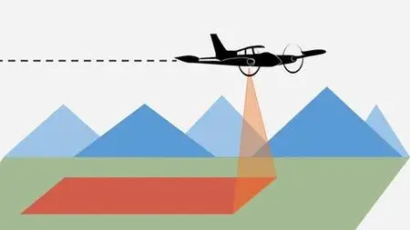
The first edition of this ground breaking reference work was the most comprehensive reference source available about the key aspects of the satellite applications field. This updated second edition covers the technology, the markets, applications and regulations related to satellite telecommunications, broadcasting and networking—including civilian and military systems; precise satellite navigation and timing networks (i.e. GPS and others); remote sensing and meteorological satellite systems. Created under the auspices of the International Space University based in France, this brand new edition is now expanded to cover new innovative small satellite constellations, new commercial launching systems, innovation in military application satellites and their acquisition, updated appendices, a useful glossary and more.

Remote Sensing for Hydrocarbon Exploration (Repost)

Posted By: AvaxGenius
Remote Sensing for Hydrocarbon Exploration (Repost)

Remote Sensing for Hydrocarbon Exploration by Andreas Laake
English | EPUB | 2022 | 394 Pages | ISBN : 3030733181 | 462.70 MB

This book provides insights into the benefits of using remote sensing data from a geoscientist's perspective, by integrating the data with the understanding of Earth's surface and subsurface. In 3 sections, the book takes a detailed look at what data explorationists use when they explore for hydrocarbon resources, assess different terrain types for planning and hazards and extract present-day geologic analogs for subsurface geologic settings.

River Ice Processes and Ice Flood Forecasting: A Guide for Practitioners and Students

Posted By: AvaxGenius
River Ice Processes and Ice Flood Forecasting: A Guide for Practitioners and Students

River Ice Processes and Ice Flood Forecasting: A Guide for Practitioners and Students by Karl-Erich Lindenschmidt
English | PDF (True) | 2024 | 493 Pages | ISBN : 3031490878 | 32.3 MB

This book exposes practitioners and decision-makers to the theory and application of river ice processes to gain a better understanding of these processes for modelling and ice flood hazard and risk assessment. It focuses on the following processes of the surface water ice: river freeze-up and flooding, mid-winter ice-cover breakup and flooding and end-of-winter ice-cover breakup and ice jamming. The reader will receive a fundamental understanding of the physical processes of each component and how they are applied in monitoring, modelling and flood hazard/risk assessment of river ice during the entire winter season, from freeze-up to potential mid-winter breakup and concluding with springtime ice-cover breakup and ice-jam flooding. Spreadsheet, geographical information system (GIS) and modelling exercises accompany each component to reinforce the theoretical principles learned. Step-by-step tutorial videos allow the reader to better engage with the book and learn the material faster.

Remote Sensing for Hydrocarbon Exploration (Repost)

Posted By: AvaxGenius
Remote Sensing for Hydrocarbon Exploration (Repost)

Remote Sensing for Hydrocarbon Exploration by Andreas Laake
English | EPUB | 2022 | 394 Pages | ISBN : 3030733181 | 462.70 MB

This book provides insights into the benefits of using remote sensing data from a geoscientist's perspective, by integrating the data with the understanding of Earth's surface and subsurface. In 3 sections, the book takes a detailed look at what data explorationists use when they explore for hydrocarbon resources, assess different terrain types for planning and hazards and extract present-day geologic analogs for subsurface geologic settings.

Photogrammetry for Production Artists

Posted By: envasel
Photogrammetry for Production Artists

Photogrammetry for Production Artists
MP4 | Video: h264, yuv420p, 1920x1080 | Audio: aac, 48000 Hz | Duration: 4h 28m | 7.53 GB
Genre: eLearning | Language: English

Capture and create your own 3D props for production using photogrammetry with this comprehensive guide for Modo, Marmoset, Photoshop, Agisoft, Lightroom, and ZBrush. In this 4-hour workshop, John William Crossland, a Lead Principal Artist at Remedy Entertainment, sheds a light on the entire process for those looking to get started with photogrammetry on a small scale. He details several ways to achieve low, medium, and high-range scans and explains how to produce a decent-quality scan that can be used as a baseline for a production asset.

Socio-Environmental Research in Latin America: Interdisciplinary Approaches Using GIS and Remote Sensing Frameworks

Posted By: AvaxGenius
Socio-Environmental Research in Latin America: Interdisciplinary Approaches Using GIS and Remote Sensing Frameworks

Socio-Environmental Research in Latin America: Interdisciplinary Approaches Using GIS and Remote Sensing Frameworks by Santiago López
English | PDF | 2023 | 307 Pages | ISBN : 3031226798 | 18.6 MB

This contributed volume presents relevant examples of socio-environmental research that highlight the challenges and opportunities of using geotechnologies in interdisciplinary settings across the vast, culturally, and environmentally mega-diverse region known as Latin America. While remote sensing has been mostly used for mapping and monitoring physical features, geographic information systems open up opportunities for the integration of socio-economic and environmental data collected through individual and community-based surveys, in-situ measurements, and other participatory research techniques to offer additional analytically grounded power when evaluating socio-environmental processes that shape Latin American landscapes.

Photogrammetry Course: Photoreal 3d With Blender And Reality Capture

Posted By: envasel
Photogrammetry Course: Photoreal 3d With Blender And Reality Capture

Photogrammetry Course: Photoreal 3d With Blender And Reality Capture
MP4 | Video: h264, yuv420p, 1920x1080 | Audio: aac, 48000 Hz | Duration: 15h | 12.6 GB
Genre: eLearning | Language: English

We believe this might be *the most* comprehensive photogrammetry video course, hands down. The course that will teach you how to make hyper-realistic 3d assets from photos. And not simply ‘any’ 3d assets, but the ones that are professional and clean and will enhance the realism of your 3d environments, like nothing else.

Satellite Measurements of Clouds and Precipitation: Theoretical Basis

Posted By: AvaxGenius
Satellite Measurements of Clouds and Precipitation: Theoretical Basis

Satellite Measurements of Clouds and Precipitation: Theoretical Basis by Hirohiko Masunaga
English | PDF,EPUB | 2022 | 303 Pages | ISBN : 981192242X | 67.9 MB

This book provides a thorough introductory description of the physical principles underlying the satellite remote sensing of clouds and precipitation. A diverse collection of satellite sensors is covered, including imagers, radars, and sounders over a broad spectral range from visible to microwave radiation.

Remote Sensing for Hydrocarbon Exploration

Posted By: AvaxGenius
Remote Sensing for Hydrocarbon Exploration

Remote Sensing for Hydrocarbon Exploration by Andreas Laake
English | EPUB | 2022 | 394 Pages | ISBN : 3030733181 | 462.70 MB

This book provides insights into the benefits of using remote sensing data from a geoscientist's perspective, by integrating the data with the understanding of Earth's surface and subsurface. In 3 sections, the book takes a detailed look at what data explorationists use when they explore for hydrocarbon resources, assess different terrain types for planning and hazards and extract present-day geologic analogs for subsurface geologic settings.

Remote Sensing Digital Image Analysis: An Introduction

Posted By: AvaxGenius
Remote Sensing Digital Image Analysis: An Introduction

Remote Sensing Digital Image Analysis: An Introduction by John A. Richards
English | PDF | 2013 | 503 Pages | ISBN : 3642300618 | 24.2 MB

Remote Sensing Digital Image Analysis provides the non-specialist with a treatment of the quantitative analysis of satellite and aircraft derived remotely sensed data. Since the first edition of the book there have been significant developments in the algorithms used for the processing and analysis of remote sensing imagery; nevertheless many of the fundamentals have substantially remained the same.

Elements of Photogrammetry with Application in GIS, Fourth Edition

Posted By: arundhati
Elements of Photogrammetry with Application in GIS, Fourth Edition

Paul Wolf, "Elements of Photogrammetry with Application in GIS, Fourth Edition"
English | ISBN: 0071761128 | 2014 | 696 pages | AZW3 | 17 MB

Advances in Remote Sensing for Infrastructure Monitoring

Posted By: sasha82
Advances in Remote Sensing for Infrastructure Monitoring

Advances in Remote Sensing for Infrastructure Monitoring (Springer Remote Sensing/Photogrammetry) by Vernon Singhroy
2021 | ISBN: 3030591085 | English | 374 pages | EPUB | 230 MB

Biomedical Visualisation: Volume 8

Posted By: AvaxGenius
Biomedical Visualisation: Volume 8

Biomedical Visualisation: Volume 8 by Paul M. Rea
English | PDF | 2020 | 203 Pages | ISBN : 3030474828 | 9.4 MB

This edited book explores the use of technology to enable us to visualise the life sciences in a more meaningful and engaging way. It will enable those interested in visualisation techniques to gain a better understanding of the applications that can be used in visualisation, imaging and analysis, education, engagement and training.

The Complete Photomod Professional Course

Posted By: Sigha
The Complete Photomod Professional Course

The Complete Photomod Professional Course
Video: .mp4 (1280x720, 30 fps(r)) | Audio: aac, 44100 Hz, 2ch | Size: 1.3 GB
Genre: eLearning Video | Duration: 9 lectures (2 hour, 8 mins) | Language: English

photogrammetry

Geoinformation: Remote Sensing, Photogrammetry and Geographical Information Systems

Posted By: roxul
Geoinformation: Remote Sensing, Photogrammetry and Geographical Information Systems

Gottfried Konecny, "Geoinformation: Remote Sensing, Photogrammetry and Geographical Information Systems"
English | ISBN: 0415237947 | 2002 | 264 pages | PDF | 10 MB